It appears that you're running an Ad-Blocker. This site is monetized by Advertising and by User Donations; we ask that if you find this site helpful that you whitelist us in your Ad-Blocker, or make a Donation to help aid in operating costs.

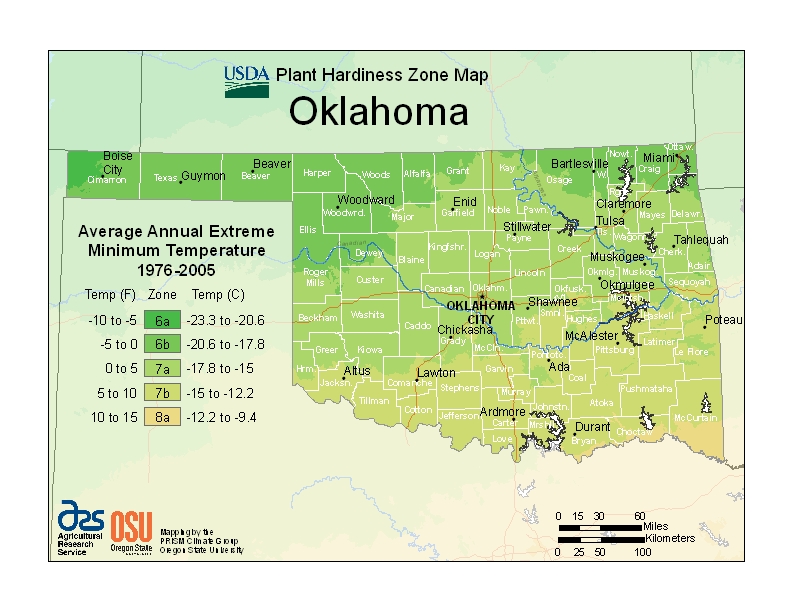
Hardiness Zone Area Data for Oklahoma (OK)

Oklahoma (OK) USDA Zone Map
▼ Sponsored Links ▼
▲ Sponsored Links ▲

State Information Data for Oklahoma (OK)

Oaklahoma City, Oklahoma; USA
Statehood November 16th, 1907
Capital Oklahoma City
Official Flag Oklahoma (OK) Flag
Approximate Size Total: 69,898 sq mi (181,195 km2)
Width: 230 miles (370 km)
Length: 298 miles (480 km)
% Water: 1.8
Highest Point Black Mesa (4,973ft or 1,516m)
Counties 77
Population 3,814,820 (2012)
Electoral Votes 7
State Quarter Issued January 28th, 2008
Official Motto Labor omnia vincit (Labor conquers all things)
Official Flower Mistletoe
Official Bird Scissor-tailed Flycatcher
Nickname Sooner State
Area Code(s) 405, 580, 918
Sports NBA: Oklahoma City Thunder
Posted By Gremelin Posted on May 8th, 2014 · Updated on August 11th, 2019
▼ Sponsored Links ▼
▲ Sponsored Links ▲

Comments

( Posted)

Related Products

▼ Sponsored Links ▼
▲ Sponsored Links ▲
Donate Today